$144.95
38, 38A, 38B, 38C, 38G, 120F, and a Chart Tube.
The best chart we've ever seen for detail in the Northern Bahamas! Complete coverage of the Little Bahama Bank including Grand Bahama and Walkers Cay east to Little Abaco. Also includes details for West End and Walkers Cay. The reverse side continues south and east through the popular cruising area of the Sea of Abaco to Cherokee Sound, and includes detailed blown up insets for Green Turtle, Treasure Cay, Whale Cay, Marsh Harbor, Little Harbor, Man O'War Cay, and Hopetown.
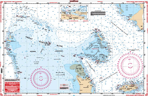
The clearest overall view of the Central Bahamas! Covers area from Bimini east to South Abaco (Hole in the Wall) and south to Nassau on one side with a detailed blow up of Nassau Harbor. Includes all the Berry Islands and North Andros. The reverse side begins at Nassau and continues east to Eleuthra and south thru the Exumas to Great Exuma and Georgetown! Continuous coverage of Eleuthra. Detailed blow ups for Georgetown, Ships Channel, Allen and Highbourn Cay in the Exumas and Harbor Island and Spanish Wells on Eleuthra.
Detailed coverage for the west portion of Grand Bahama Island from the Missle Base east. Includes the Grand Bahama Waterway, all southside marinas and canals, and the Commercial Harbor. Waypoints are provided for all harbor entrances and for the Indian Key Channel. An added red pattern details the south side barrier reef. Detail entrance diagram for Port Lucaya. The reverse side covers the Berry Islands in detail from Great Stirrup south to Chub Cay.
Out of stock
This exceptional nautical map features fishing and diving information available from no other source. We contact our trusted local sources to give our marine charts that extra special sauce. That sauce? It's insider information on the best fishing spots in the area. Exceptional bright colors make this Bahamas fishing chart easy to read and excellent for framing and hanging at home or the office.
Side A is an enlarged projection of Florida's South East Coast from Stuart south to Elliot Key and east to include the Abacos Islands and south to include the Bimini and Berry Islands. Side B includes South Florida, Cuba, and the Bahama Islands south and east to the northwest coast of Haiti. This is a great chart for planning your trip to the Abacos or anywhere in the Bahamas. This map of the Bahamas needs to be in your boat's glovebox.
The best chart for crossing to the Bahamas! Details the Florida coast from Jupiter south to Key Largo, and covers the Bimini chain of Islands and the West End of Grand Bahama. Included on this side is a crossing guide. The reverse side has a large blow up of West End, a detailed projection of the Bimini area including Cat Cays, Gun Cay and North Rock and an extra large blow up of South Bimini and Alice Town. GPS Waypoints printed directly on the chart.
There are no reviews yet.
Your email address will not be published. Required fields are marked *
Your review *
Name *
Email *
Save my name, email, and website in this browser for the next time I comment.
 Everglades Challenge Kit
$119.95
Everglades Challenge Kit
$119.95
Reviews
There are no reviews yet.