

Description
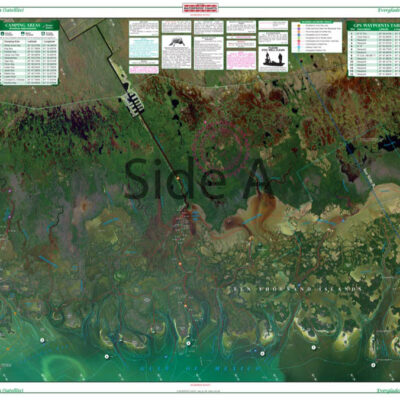
Side A of this chart includes detailed coverage of Port Charlotte and Punta Gorda, south to Pine Island, and west to Boca Grande and Cayo Costa. Side B has coverage for all of Pine Island and Matlacha Pass including the new Sword Point channel, North Captiva, Captiva, and Sanibel Islands, and south to Ft. Myers Beach and San Carlos Bay. The enhanced color scheme makes it easy to find the deep water and avoid the numerous shallows. GPS coordinates have been added throughout. Latitude and longitude lines make it easy to use with GPS. Dozens of boat ramps have been added with a listing and symbol on the chart for the trailer-boater. Large place names make your destinations easy to find. Nobody offers comprehensive navigation detail for Charlotte Harbor and Pine Island Sound quite like Waterproof Charts. We take pride in the fact that our marine charts are put together using a combination of information sources. This means you are getting a navigation chart with the most detail possible. Side A of this nautical chart includes detailed coverage of Port Charlotte FL and Punta Gorda, south to Pine Island, and west to Boca Grande and Cayo Costa. Side B has coverage for all of Pine Island Florida and Matlacha Pass including the new Sword Point channel, North Captiva, Captiva, and Sanibel Islands, and south to Fort Myers Beach and San Carlos Bay. The enhanced color scheme makes it easy to find the deep water and avoid the numerous shallows. GPS coordinates have been added throughout to help you find points of interest. Latitude and longitude lines make it easy to use with GPS. Dozens of boat ramps have been added with a listing and symbol on the chart for those of you trailoring your boat. Large place names make your destinations easy to find. Information is from NOAA charts #11426 and other local authorities. Nautical chart is 25″ X 38″. WGS84 – World Mercator Datum.


Reviews
There are no reviews yet.