Description
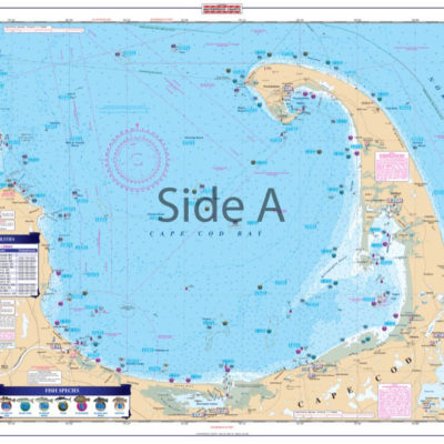
The only chart of this type. Combines 3 NOAA Fishing Charts (now out of print) with a NOAA Bathymetric on the reverse side. Inshore Coverage from Venice south to Sanibel and out to 80 feet deep showing bottom characteristics and featuring 6 different types of bottom conditions: shell, mud, coral, rock, gravel and sand. Each bottom type is colored and identified by GPS coordinates. The reverse side covers further offshore to 180 feet deep with full bathymetric detail. Plotted and indexed artificial reefs and wrecks and holes on both sides. The only fishing chart of its type. You really won’t find anything else like this around! Why? Becuase we have the inside scoop! Our fishing charts contain local knowledge from professional fishermen. These marine charts combine 3 NOAA Charts (now out of print) with a NOAA Bathymetric on the reverse side. You’ll find inshore coverage from Venice south to Sanibel and out to 80 feet deep, showing bottom characteristics and featuring 6 different types of bottom conditions: shell, mud, coral, rock, gravel and sand. Each bottom type is distinctively colored and identified by GPS coordinates. The reverse side of this navigation map covers further offshore to 180 feet deep with full bathymetric detail. Plotted and indexed artificial reefs and wrecks and holes on both sides will help you find the fishing hot spots. A total of 270 GPS coordinates include useful fishing features. After seeing the vibrant colors, you will want this navigation chart framed to display in your home or office. Nautical Chart is 25″ X 38″. WGS84 – World Mercator Datum.

Reviews
There are no reviews yet.