$99.95
21F, 22F, 30F, 31F, and 89F.
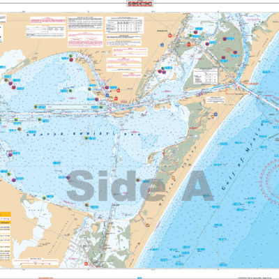
This is a must have for the fishing enthusiast that is in search of the best Redfish, Trout, Snook, and Tarpon fishing spots in the Sarasota Area. This large print chart has all of Sarasota Bay on one side and the Intracoastal Waterway from Sarasota Bay to Venice on the back side. As well as all of the major grass flats, we have pinpointed dozens of specific areas for the major species caught in the area. In addition we have added high accuracy GPS positions for the popular bay reefs.
Covers the area from the ship channel inshore, coastal coverage from Treasure Island to Anna Maria, up the Manatee River to the I-75 bridge, and the entire Tampa Bay and Old Tampa Bay to Safety Harbor. This special chart details all the major grass flat areas and pinpoints dozens of specific areas for the major species caught in the area: Cobia, Mackeral, Snook, Grouper, Redfish, Tarpon and Trout. In addition, there are 64 listings, plotted and indexed for reefs, wrecks, and fish-holding structure with high accuracy GPS positions and major target species combined with a separate GPS table for navigational aids to help you set up your GPS.
Complete Inshore coverage from the Cross River Barge Canal to Horseshoe Point. We have detailed all the Grass Flats, and include names of all the major creeks. As with all Inshore Fishing Charts, we have preplotted many GPS Coordinates, and species specific areas to find the most popular fish caught in that area. We have listed all the major public boat ramps as well. If you are planning a trip to this area you will want to add this to your list of "Must Haves".
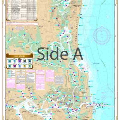
The newest addition to our complete line of Inshore Fishing Charts, this 2 sided, large print, folded chart has complete coverage from Clearwater Pass to Crystal River. This special chart details all of the major grass flats, oyster reefs, and pinpoints dozens of specific areas for the species caught in that area. A handy marine facilities guide gives over 15 boat ramps, as well as information where you can buy bait or fuel. Like all of our Inshore Fishing Charts, this latest one comes inserted in an easy to store folder, with a beautiful artist rendering of a fish caught in area.
This great combination of three NOAA charts covers from Horseshoe Beach north to Keaton and Dekle Beach, including the Steinhatachee River, with detailed insets of Horseshoe Beach and the Steinhatchee River.
There are no reviews yet.
Your email address will not be published. Required fields are marked *
Your review *
Name *
Email *
Save my name, email, and website in this browser for the next time I comment.

 Everglades Challenge Kit
$119.95
Everglades Challenge Kit
$119.95
Reviews
There are no reviews yet.