

Description
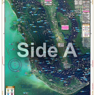
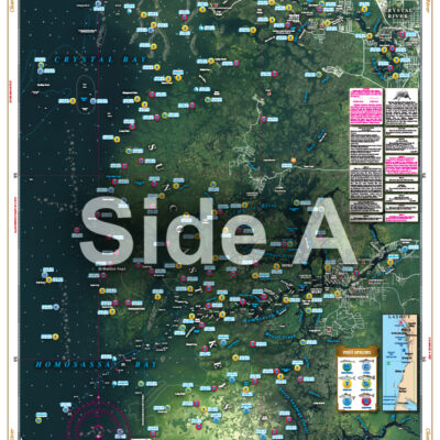
Covers the area from the ship channel inshore, coastal coverage from Treasure Island to Anna Maria, up the Manatee River to the I-75 bridge, and the entire Tampa Bay and Old Tampa Bay to Safety Harbor. This special chart details all the major grass flat areas and pinpoints dozens of specific areas for the major species caught in the area: Cobia, Mackeral, Snook, Grouper, Redfish, Tarpon and Trout. In addition, there are 64 listings, plotted and indexed for reefs, wrecks, and fish-holding structure with high accuracy GPS positions and major target species combined with a separate GPS table for navigational aids to help you set up your GPS. A handy marine facilities guide gives detailed information on 50 different boat ramps, marinas, and bait and tackle stores all shown on the chart. If you’re fishing the Tampa Bay area, this is the one chart to have! The search is over! The most comprehensive Tampa Bay Fishing Chart is here! It covers the area from the ship channel inshore, coastal coverage from Treasure Island to Anna Maria, up the Manatee River to the I-75 bridge, and the entire Tampa Bay and Old Tampa Bay to Safety Harbor. This special navigation chart details all the major grass flat areas and pinpoints dozens of specific areas for the major species caught in the area: Cobia, Mackeral, Snook, Grouper, Redfish, Tarpon and Trout. In addition, there are 64 listings, plotted and indexed for reefs, wrecks, and fish-holding structure with highly accurate GPS positions and major target species combined with a separate GPS table for navigational aids to help you set up your GPS unit. A handy marine facilities guide gives detailed information on 50 different boat ramps, marinas, and bait and tackle stores all shown on the nautical map. If you’re fishing the Tampa Bay area, this is the one navigation map to have two of! What? Yes two! One for your vessel, and another to frame majestically on your wall. Information from 2 NOAA charts: #11415 and #11416. Nautical chart is 25″ X 38″. WGS84 – World Mercator Datum.


Reviews
There are no reviews yet.